
Year-Round Aerial Mapping in Precision Farming – 2018 Agricultural White Paper
Mar 8, 2018
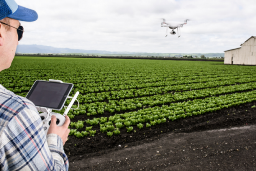
Aerial Imagery has created the opportunity to review side-by-side maps & integrate new data with historical field data, such as soils, irrigation, planting & more; resulting in precision farming.
Milford, United States - March 8, 2018 /PressCable/ —
More farmers are now taking advantage of aerial technology and remote sensing data to Precision Farming decision-making. Aerial Imagery is rapidly becoming a routine year-round procedure in the management of crop workflow.
Frank Segarra, President at Connexicore, is pleased to announce the availability of the 2018 Agriculture Whitepaper. Mr. Segarra goes on to say, “It’s really not a surprise that Drones now have a year-round presence in agriculture. From using drone maps to assess drainage tiles to determine if irrigation systems are functioning correctly, to using an elevation map to assess the slope of a field to determine if new drainage tile is needed, drones play an ever increasing role in planning. It’s not unusual for the resultant plan to show both the location and number of tiles needed to get the job done.”
With over 20 years of industry experience, ConnexiCore is deeply engaged in several inter-related aspects of drone management in Agriculture. Click here to see video.
DRAINAGE AND IRRIGATION
Here’s how aerial imagery is making a difference. A bare earth map enables the farmer to catch drainage and irrigation issues early, before they turn into bigger problems next growing season. This kind of mapping can easily be done before the ground freezes.
To best view drainage tiles, field mapping is done in the morning after a rain, when the soil is still wet but beginning to dry out. Aerial Imagery will show the red areas as being the driest and the green areas are still relatively wet, indicating the field might not be draining as fast as the rest of the field. Often times reference to an elevation map is useful.
Although a standard drone map (without the use of ground control points) shouldn’t be used to determine the actual coordinates for laying drainage tiles, it can still help you assess how a field slopes, decide if tile is needed, and make a general plan for the location and number of tiles. Doing this in the off season is most appropriate.
Another Resource is the RGB Map, useful to detect potential problem areas with an above-surface irrigation system. Excess water may build below the surface before any issues can be seen above ground. By reviewing a RGB map a lot of irrigation issues, like flat or sunken tires, or plugged nozzles, can be spotted early.
USING HISTORICAL AERIAL DATA
Aerial imagery from different times of the growing season can be very useful. This means the same drone maps used at the height of the growing season to make a difference are also invaluable when it comes time for a post-season debrief.
By reviewing side-by-side maps and integrating this new data with historical field data, such as soil type, soil sample, planting, and yield data, you gain a true picture of field’s performance. With a greater understanding of what happened, exactly where it happened, and at what point in time, you can make smarter crop management decisions to maximize next year’s yield. This is the whole key about Precision Farming. Better decisions are being made.
MORE DATA MEANS MORE OPTIONS & BETTER DECISIONS in FARMING
Drone maps are used with other information, including harvest, yield, variety, and spraying maps. This means all you have to do is import the necessary field maps from the software, meaning all you need to do is export the ortho-mosaic, plant health, and elevation maps. The end result is a complete history of how crops are being grown.
As spring arrives and planting approaches, mapping the bare field one last time is a good strategy. A preseason barren earth map, combined with targeted ground-truthing, helps one understand what pests and weeds have come up as a result of heavy rains or severe weather.
NEED FOR SEASONAL FLIGHT PLANNING
Just as the off season is the time to take stock of equipment, maintenance, and staffing needs, it’s also the time to create a seasonal flight plan. Flying at regular intervals creates a consistent record of what a field looks like over time and gives you more information to work with when it comes time to make those big, mid-season decisions.
Go into the busiest months with a pre-established calendar. The value of a particular crop and the distance of the field from your headquarters will also be a key factor in determining flight schedules. Strive for flying the most convenient and high-value crops each week, and the less convenient crops biweekly.
HERE’S A SUGGESTED MONTHLY CHECKLIST TO SUPPORT PRECISION FARMING:
JAN/FEB: Purchase Equipment, Necessary software, Drone service
MAR: Soil Mapping, Historical maps
APR: Planting
MAY: Replanting
JUN/JUL/AUG: Crop Scouting, Application decisions, Irrigation Needs, Yield projections
SEP: Harvest
OCT: Drainage Repair
NOV/DEC: Evaluate & Plan
The 2018 Agricultural White Paper reviews innovative strategies of geo-spatial imagery for Precision Farming. The document highlights additional innovative and new groundbreaking information technologies.
Contact Kim Kersten at 800-874-9640 Ext 703 or [email protected] for a copy of the 2018 Agricultural White Paper
More information is available at http://www.connexicore.com.
Contact Info:
Name: Kim Kersten
Email: [email protected]
Organization: ConnexiCore
Address: 307 Oneida Way, Milford, PA 18337, United States
Phone: +1-800-874-9640
For more information, please visit http://www.connexicore.com
Source: PressCable
Release ID: 309573
More News








Recommended








YOUR NEWS, OUR NETWORK.
Do you have Great News you want to tell the world?
Be it updates about your business or your community, you can make sure that it’s heard by submitting your story to our network reaching hundreds of news sites across 6 verticals.